


Mount St. Helens Climbing - 364S
Pickup available at Whittaker Mountaineering
Usually ready in 24 hours
Mount St. Helens Climbing - 364S
Whittaker Mountaineering
30027 SR 706 E
Ashford WA 98304
United States
Description
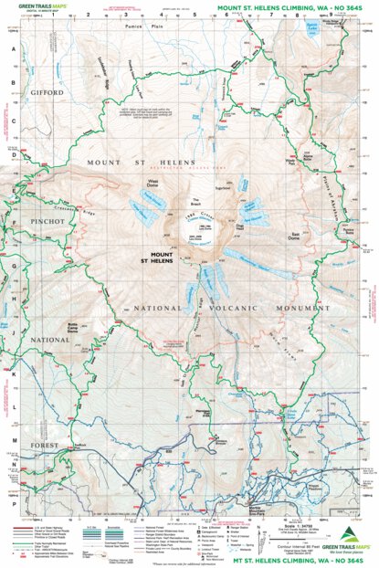
Essential navigation for the crater rim and beyond.
Green Trails Map 364S is a specialized tool designed specifically for summiting and circumnavigating Mount St. Helens. With a highly detailed 1:34,750 scale, it offers precise topography for navigating the climbing routes to the crater rim as well as the complete 29-mile Loowit Trail. Whether you are skinning up from Marble Mountain Sno-Park in winter or scrambling the Ptarmigan Trail in summer, this map provides critical data on water sources, campsites, and route realignments in this shifting volcanic landscape.
Details & Features
Specs & Materials
Sizing
See Specs tab for Sizing Details
Essential navigation for the crater rim and beyond.
Green Trails Map 364S is a specialized tool designed specifically for summiting and circumnavigating Mount St. Helens. With a highly detailed 1:34,750 scale, it offers precise topography for navigating the climbing routes to the crater rim as well as the complete 29-mile Loowit Trail. Whether you are skinning up from Marble Mountain Sno-Park in winter or scrambling the Ptarmigan Trail in summer, this map provides critical data on water sources, campsites, and route realignments in this shifting volcanic landscape.
See Specs tab for Sizing Details

We Simplify
Outfitting
Whittaker Mountaineering was born out of the need for RMI to make sure their clients had the appropriate gear to get to the top of Mt. Rainier safely. After decades of trying, reviewing, arguing-over, and recommending gear, we can’t help but know what we’re doing by this point. We know what works, we know what doesn’t, and we use that expertise to stock our store.
- Free Shipping On orders over $150
- Easy Returns - 30 days, no hassle returns