Tatoosh Ridge
Permit: Wilderness permit (self-issued at trailhead)
Length: 6.2 Miles Round Trip
Elevation: 2900 ft, highest point 5775 ft
Difficulty: Hard
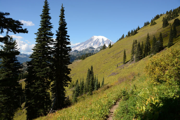
A long hike with significant elevation, peaking out to a beautiful view of Rainier and wildflowers that are hard to beat.
Description
With a beautiful view of Rainier, stunning wildflowers, and the option to detour to an alpine lake and/or Tatoosh Peak, it’s hard to beat Tatoosh Ridge when it comes to day hikes near the park. There are two trailheads you can use to get to Tatoosh Ridge, but the north trailhead is the best. The beginning is steep but fairly well shaded (keep an eye out for blueberries, huckleberries, and wild strawberries) until about 2 miles in. At 2.4 miles, there is a faint trail to the left, which leads to a viewpoint of Rainier after 0.3 miles, and eventually into the National Park. But the views of Rainier are much better if you continue on the main trail. The trail may be covered by snow and even in summer months can be obscured by vegetation, so map reading and navigational skills may come in handy. At 5600 feet, you’ll see a split in the trail, with the right continuing onto Tatoosh Ridge and the left leading up over a spine and then dropping 600 feet to two gorgeous alpine lakes. The main ridge trail continues south east, with views of Rainier blossoming behind you, until a small pass at about the 3 mile mark makes for a natural turn-around point. If you choose to keep going, Trail 161A (reached after 4.5 miles from the trailhead) will take you up onto Tatoosh Peak, which is quite exposed and often windy, so travel with care.
Directions/ Road Conditions
From Ashford, continue on WA-706 for 2.5 miles, then take a right on Skate Creek (Kernahan) road. After almost 19 miles, turn left onto NF-5270. After about 5 miles, NF-5270 turns slightly right and becomes NF-5272, which you should continue on for another 1.5 miles until you see the trailhead on the right.
Coordinates: 46.7131, -121.7158
Current Conditions:
Due to it's elevation, there is usually snow on Tatoosh Ridge well into the summer. Check AllTrails and WTA for current conditions!


