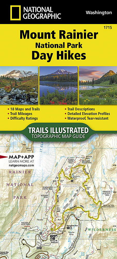
Designed for hiking enthusiasts of all abilities, the National Geographic Mount Rainier National Park Day Hikes topographic map guide provides key info on 18 stellar hikes to get you out exploring.
The Mount Rainier National Park Day HikesTopographic Map Guide contains detailed maps for 18 of Mount Rainier's finest day hikes. It includes well-known hikes and some off-the-beaten-path trails. They range from easy strolls to strenuous climbs, selected to give you a sampling of all the park has to offer. Together, they cover more than 100 miles of adventures. One-third of the selected hikes are less than 6 miles long, two-thirds are less than 8 miles, and one hike is 13 miles long.
Each of the 18 maps include directions to the trailhead, the total distance to complete the hike, and an estimate of the degree of difficulty. Also provided are elevations of key points on the trail, an elevation profile for the hike, and a calculation of the hike's total elevation gain. Concise trail descriptions will help you find the hikes that best suit your interests, conditioning, and available time.
Every Trails Illustrated map is printed on "Backcountry Tough" waterproof, tear-resistant paper. A full UTM grid is printed on the map to aid with GPS navigation. Every map purchase helps support the National Geographic Society, an impact driven, nonprofit organization with global reach that uses the power of science, exploration, education, and storytelling to illuminate and protect the wonder of our world.
Contains detailed maps for 18 of Mount Rainier's finest day hikes—including well-known hikes and some off-the-beaten-path trails
Hikes range from easy strolls to strenuous climbs, giving you a sampling of all the park has to offer; together they cover more than 100 miles
One-third of the selected hikes are less than 6 miles long, two-thirds are less than 8 miles long, and one hike is 13 miles long
Each of the 18 maps includes directions to the trailhead, the total distance to complete the hike and an estimate of the degree of difficulty
Maps also provide elevations of key points on the trail, an elevation profile for the hike and a calculation of the hike's total elevation gain
Concise trail descriptions will help you find the hikes that best suit your interests, conditioning and available time
Printed on "Backcountry Tough" waterproof, tear-resistant paper
Map booklet contains 42 pages
Every map purchase helps support the National Geographic Society, an impact-driven, nonprofit organization
Folded Dimensions: 9.25 x 4.25 inches
Map Scale: 1:31,680
Double Sided: yes
Waterproof: yes
Copyright Year: 2023
Description
Designed for hiking enthusiasts of all abilities, the National Geographic Mount Rainier National Park Day Hikes topographic map guide provides key info on 18 stellar hikes to get you out exploring.
The Mount Rainier National Park Day HikesTopographic Map Guide contains detailed maps for 18 of Mount Rainier's finest day hikes. It includes well-known hikes and some off-the-beaten-path trails. They range from easy strolls to strenuous climbs, selected to give you a sampling of all the park has to offer. Together, they cover more than 100 miles of adventures. One-third of the selected hikes are less than 6 miles long, two-thirds are less than 8 miles, and one hike is 13 miles long.
Each of the 18 maps include directions to the trailhead, the total distance to complete the hike, and an estimate of the degree of difficulty. Also provided are elevations of key points on the trail, an elevation profile for the hike, and a calculation of the hike's total elevation gain. Concise trail descriptions will help you find the hikes that best suit your interests, conditioning, and available time.
Details/Features
Every Trails Illustrated map is printed on "Backcountry Tough" waterproof, tear-resistant paper. A full UTM grid is printed on the map to aid with GPS navigation. Every map purchase helps support the National Geographic Society, an impact driven, nonprofit organization with global reach that uses the power of science, exploration, education, and storytelling to illuminate and protect the wonder of our world.
Contains detailed maps for 18 of Mount Rainier's finest day hikes—including well-known hikes and some off-the-beaten-path trails
Hikes range from easy strolls to strenuous climbs, giving you a sampling of all the park has to offer; together they cover more than 100 miles
One-third of the selected hikes are less than 6 miles long, two-thirds are less than 8 miles long, and one hike is 13 miles long
Each of the 18 maps includes directions to the trailhead, the total distance to complete the hike and an estimate of the degree of difficulty
Maps also provide elevations of key points on the trail, an elevation profile for the hike and a calculation of the hike's total elevation gain
Concise trail descriptions will help you find the hikes that best suit your interests, conditioning and available time
Printed on "Backcountry Tough" waterproof, tear-resistant paper
Map booklet contains 42 pages
Every map purchase helps support the National Geographic Society, an impact-driven, nonprofit organization
Redeem points for discounts on your next purchase.
We clean up after ourselves.
Ecommerce deliveries have a carbon footprint. That's why we support verified projects that remove carbon from the air.
PARTICIPATING BRANDS AND CUSTOMERS HAVE HELPED FUND
57+million
Carbon-neutral orders
41+thousand
Tonnes of carbon removed
THAT'S LIKE...
5billion
Smartphones charged
170million
Kilometers driven by a gasoline-powered car
HOW IT WORKS
Every delivery’s carbon footprint is calculated based on weight, shipping method, and distance traveled. We neutralize these emissions by purchasing verified carbon removal credits from groundbreaking projects.
MAKING A DIFFERENCE
With your purchase, you’ll join a community of proactive merchants and customers dedicated to a sustainable future. Together, we've removed emissions for over 57 million deliveries and removed over 41 thousand tonnes of carbon.
FUTURE-PROOFING OUR PLANET
We work with a network of pioneering carbon removal companies that have been vetted by the commerce platform Shopify.
Carbon-neutral shipping on all orders
1742kg
shipping emissions removed
That's like...
4458
miles driven by an average gasoline-powered car
Use left/right arrows to navigate the slideshow or swipe left/right if using a mobile device
Choosing a selection results in a full page refresh.
Press the space key then arrow keys to make a selection.