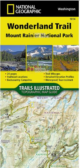
Navigate the 22,000 Cumulative Feet of Elevation Gain/loss Over Undulating Terrain Encircling Mount Rainier
The Wonderland Trail encircles Mount Rainier and was completed in 1915 by volunteers and designated a National Recreation Trail in 1981. The Wonderland Trail is known for its undulating terrain with a striking cumulative 22,000 feet of elevation gains and losses.
TheTopographic Map Guideis arranged for clockwise travel around the Wonderland Trail starting at the Sunrise trailhead. Each map page has a detailed trail profile that shows the elevation changes you will encounter. Also, the Wonderland Trail is highlighted and centered on each page so you can easily track your progress. TheTopographic Map Guidealso includes information about Mt Rainier National Park as well as wilderness regulations and other important facts and tips to help make your journey on this amazing trail both successful and memorable.
More convenient and easier to use than folded maps, but just as compact and lightweight, National Geographic’sTopographic Map Guidebooklets are printed on "Backcountry Tough" waterproof, tear-resistant paper with stainless steel staples. A full UTM grid is printed on the map to aid with GPS navigation.
Includes detailed topographic maps, interesting history and bike detour maps
Arranged for clockwise travel around the Wonderland Trail starting at the Sunrise trailhead
24-page booklet design is more convenient and easier to use than a folded map but just as compact and lightweight
Each page is centered on the Wonderland Trail to overlap with adjacent pages and simplify navigation; a printed UTM grid aids with navigation
Trail profiles along the bottom of each page detail elevation changes, distance between passes, camping areas and access points
A resupply location chart shows distances to and services available at resupply points
Provides information about Mount Rainier National Park as well as wilderness regulations and other important facts and tips to help make your journey successful
Printed on Backcountry Tough waterproof, tear-resistant paper with stainless-steel staples
Your purchase helps support National Geographic Society nonprofit's mission of research, education, conservation and exploration
The Wonderland Trail was completed in 1915 by volunteers and designated a National Recreation Trail in 1981
Folded Dimensions: 9.25 x 4.25 inches
Map Scale: 1:55,000
Double Sided: yes
Waterproof: yes
Copyright Year: 2018
Description
Navigate the 22,000 Cumulative Feet of Elevation Gain/loss Over Undulating Terrain Encircling Mount Rainier
The Wonderland Trail encircles Mount Rainier and was completed in 1915 by volunteers and designated a National Recreation Trail in 1981. The Wonderland Trail is known for its undulating terrain with a striking cumulative 22,000 feet of elevation gains and losses.
TheTopographic Map Guideis arranged for clockwise travel around the Wonderland Trail starting at the Sunrise trailhead. Each map page has a detailed trail profile that shows the elevation changes you will encounter. Also, the Wonderland Trail is highlighted and centered on each page so you can easily track your progress. TheTopographic Map Guidealso includes information about Mt Rainier National Park as well as wilderness regulations and other important facts and tips to help make your journey on this amazing trail both successful and memorable.
More convenient and easier to use than folded maps, but just as compact and lightweight, National Geographic’sTopographic Map Guidebooklets are printed on "Backcountry Tough" waterproof, tear-resistant paper with stainless steel staples. A full UTM grid is printed on the map to aid with GPS navigation.
Details/Features
Includes detailed topographic maps, interesting history and bike detour maps
Arranged for clockwise travel around the Wonderland Trail starting at the Sunrise trailhead
24-page booklet design is more convenient and easier to use than a folded map but just as compact and lightweight
Each page is centered on the Wonderland Trail to overlap with adjacent pages and simplify navigation; a printed UTM grid aids with navigation
Trail profiles along the bottom of each page detail elevation changes, distance between passes, camping areas and access points
A resupply location chart shows distances to and services available at resupply points
Provides information about Mount Rainier National Park as well as wilderness regulations and other important facts and tips to help make your journey successful
Printed on Backcountry Tough waterproof, tear-resistant paper with stainless-steel staples
Your purchase helps support National Geographic Society nonprofit's mission of research, education, conservation and exploration
The Wonderland Trail was completed in 1915 by volunteers and designated a National Recreation Trail in 1981
Redeem points for discounts on your next purchase.
We clean up after ourselves.
Ecommerce deliveries have a carbon footprint. That's why we support verified projects that remove carbon from the air.
PARTICIPATING BRANDS AND CUSTOMERS HAVE HELPED FUND
57+million
Carbon-neutral orders
41+thousand
Tonnes of carbon removed
THAT'S LIKE...
5billion
Smartphones charged
170million
Kilometers driven by a gasoline-powered car
HOW IT WORKS
Every delivery’s carbon footprint is calculated based on weight, shipping method, and distance traveled. We neutralize these emissions by purchasing verified carbon removal credits from groundbreaking projects.
MAKING A DIFFERENCE
With your purchase, you’ll join a community of proactive merchants and customers dedicated to a sustainable future. Together, we've removed emissions for over 57 million deliveries and removed over 41 thousand tonnes of carbon.
FUTURE-PROOFING OUR PLANET
We work with a network of pioneering carbon removal companies that have been vetted by the commerce platform Shopify.
Carbon-neutral shipping on all orders
1746kg
shipping emissions removed
That's like...
4469
miles driven by an average gasoline-powered car
Use left/right arrows to navigate the slideshow or swipe left/right if using a mobile device
Choosing a selection results in a full page refresh.
Press the space key then arrow keys to make a selection.