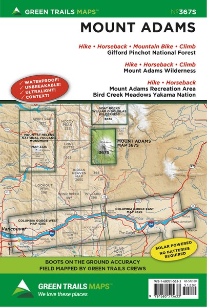
The Green Trails Mount Adams, WA Map shows the most current trail, road, and access information to Mount Adams, in the most clear, compact, and convenient format and scale available. Featuring Gifford Pinchot National Forest, Mount Adams Wilderness, Mount Adams Recreation Area, Yakama Nation, and Bird Creek Meadows, use this map to navigate this beautiful area of Mount Adams.
Washington’s second highest peak offers as much rugged alpine beauty and stunning trails as its more popular volcanic counterparts, Mounts Rainier and Hood. This (Scale 1:69500) map covers nearly all of the Mount Adams Wilderness as well as the Yakama Nation Mount Adams Recreation Area. Map is integral for anyone planning to summit the 12,276-foot glacier shrouded behemoth. The map also highlights the Pacific Crest Trail from FR 23 to Muddy Fork Creek. Exceptional day hikes and extended trips showcased on this map include; Bird Creek Meadows, the Round-the-Mountain Trail, Adams Creek Meadows, and Devils Garden. Map includes popular equestrian trails near Gotchen Creek, Morrison Creek, and Snipes Mountain. Horseshoe Lake, Chain of Lakes, and Takhlakh Lake’s trail systems are also shown on this map.
Original Issue : 2010Scale : 1:63,360/1:24,000
Projection : Varies
UTM Zone : 10
Datum : NAD83
Sheet Size/Type : 22.5x30 Inch
Folded : 6x9 Inch
Description
Don't Get Lost Out There
The Green Trails Mount Adams, WA Map shows the most current trail, road, and access information to Mount Adams, in the most clear, compact, and convenient format and scale available. Featuring Gifford Pinchot National Forest, Mount Adams Wilderness, Mount Adams Recreation Area, Yakama Nation, and Bird Creek Meadows, use this map to navigate this beautiful area of Mount Adams.
Details/Features
Washington’s second highest peak offers as much rugged alpine beauty and stunning trails as its more popular volcanic counterparts, Mounts Rainier and Hood. This (Scale 1:69500) map covers nearly all of the Mount Adams Wilderness as well as the Yakama Nation Mount Adams Recreation Area. Map is integral for anyone planning to summit the 12,276-foot glacier shrouded behemoth. The map also highlights the Pacific Crest Trail from FR 23 to Muddy Fork Creek. Exceptional day hikes and extended trips showcased on this map include; Bird Creek Meadows, the Round-the-Mountain Trail, Adams Creek Meadows, and Devils Garden. Map includes popular equestrian trails near Gotchen Creek, Morrison Creek, and Snipes Mountain. Horseshoe Lake, Chain of Lakes, and Takhlakh Lake’s trail systems are also shown on this map.
Redeem points for discounts on your next purchase.
We clean up after ourselves.
Ecommerce deliveries have a carbon footprint. That's why we support verified projects that remove carbon from the air.
PARTICIPATING BRANDS AND CUSTOMERS HAVE HELPED FUND
64+million
Carbon-neutral orders
46+thousand
Tonnes of carbon removed
THAT'S LIKE...
5billion
Smartphones charged
192million
Kilometers driven by a gasoline-powered car
HOW IT WORKS
Every delivery’s carbon footprint is calculated based on weight, shipping method, and distance traveled. We neutralize these emissions by purchasing verified carbon removal credits from groundbreaking projects.
MAKING A DIFFERENCE
With your purchase, you’ll join a community of proactive merchants and customers dedicated to a sustainable future. Together, we've removed emissions for over 64 million deliveries and removed over 46 thousand tonnes of carbon.
FUTURE-PROOFING OUR PLANET
We work with a network of pioneering carbon removal companies that have been vetted by the commerce platform Shopify.
Carbon-neutral shipping on all orders
2643kg
shipping emissions removed
That's like...
6766
miles driven by an average gasoline-powered car
Use left/right arrows to navigate the slideshow or swipe left/right if using a mobile device
Choosing a selection results in a full page refresh.
Press the space key then arrow keys to make a selection.